Marine Weather and Tide Forecast for Ephraim, WI
May 5, 2024 12:23 PM CDT (17:23 UTC) Change Location
 | Sunrise 5:34 AM Sunset 8:03 PM Moonrise 4:14 AM Moonset 5:13 PM |
LMZ541 Rock Island Passage To Sturgeon Bay Wi- 1157 Am Cdt Sun May 5 2024
This afternoon - S wind 5 to 10 kts. Mostly Sunny. Waves 2 ft or less.
Tonight - SE wind 5 to 10 kts. Mostly clear. Waves 2 ft or less.
Monday - SE wind 5 to 10 kts. Sunny. Waves 2 ft or less.
Monday night - SE wind 10 to 15 kts. Mostly clear. Waves 2 ft or less.
LMZ500
No data
No data

Area Discussion for - Green Bay, WI
(hide/show) HelpNOTE: mouseover dotted underlined text for definition
FXUS63 KGRB 051701 AFDGRB
Area Forecast Discussion National Weather Service Green Bay WI 1201 PM CDT Sun May 5 2024
Updated aviation portion for 18Z TAF issuance
KEY MESSAGES
- Patchy dense fog this morning, mainly across central and northern WI. Otherwise, quiet conditions expected today into Monday.
- Relative humidity dropping into the upper 20s and 30s this afternoon and Monday afternoon. Recent rain, lack of gusty winds and continued green-up will limit fire weather concerns.
- Next round of showers and storms arrives Tuesday morning. Best chance for non-severe thunderstorms will be Tuesday afternoon and evening.
DISCUSSION
Issued at 345 AM CDT Sun May 5 2024
Short Term
Today
Tonight...and Monday
Quiet early May weather on tap for the region today into Monday.
Only weather concerns will be fog/frost potential and low RH's each afternoon.
Precip / Clouds / Fog:
High pressure will build across the Great Lakes today, slowly sliding to our east on Monday, bringing dry conditions. Fog, locally dense, will continue across parts of central and northern WI early this morning. May need a SPS if the fog can become a little more dense/widespread. So far satellite and webcams are showing more patchy ground fog. The low clouds and fog will lift/burn off after sunrise, leaving sunny skies. Then look for fair weather cumulus to develop later this morning into the afternoon as we hit our daytime convective temps. These will fade in the mid-late afternoon, with clear skies expected tonight. Fog potential tonight looking very low as the lower levels dry out even more and winds just off the surface remain between 10-20 kts.
Plenty of sunshine is expected on Monday with only a few fair weather cumulus expected in the late morning and afternoon. As flow turns back to the south/southeast on Lake Michigan late tonight into Monday, a few lake clouds or even a little fog will be possible.
Winds / Relative Humidity:
Northwest winds will shift to the west and gust up to around 15 mph today. As return flow sets up on Monday, southeast winds could gust up to 20 mph. Afternoon relative humidities are forecast to drop into the upper 20s and 30s this afternoon and Monday afternoon, lowest in the sandy soil regions. Recent rain and lack of gusty winds will limit any fire weather concerns today.
Slightly elevated fire weather conditions are possible on Monday as soils dry out and slightly warmer temps are expected, especially over northern WI where the green-up has been the slowest.
Temps / Frost Potential:
925/850mb temps support highs in the 60s to around 70 today. A lake breeze will keep afternoon temps cooler near Lake Michigan.
Lows tonight are forecast to drop into the 30s across much of the Northwoods. Some of the colder spots in central WI could also drop into the upper 30s. Frost is looking likely over northern WI, but frost/freeze headlines have not begun yet. Further south, some patchy frost will be possible in the cold spots of central WI.
925/850mb temps increase slightly on Monday, so most spots should be a a couple/few degrees warmer than today.
Long Term...Monday Night Through Saturday
Monday night through Tuesday...Focus of the extended forecast remains on a well organized system shifting over the northern Plains Tuesday. A warm air advection regime and deep layer moisture (PWAT values 1-1.3") out in front of this system will likely bring an initial round of rain to the region Tuesday morning spreading from southwest to northeast. There will be some dry air to overcome in front of this system, so areas in east- central and northeast WI may not see rain arrive until Tuesday afternoon. Best chance for thunderstorms comes Tuesday afternoon and evening as models show a thin band of instability (MUCAPE 200- 500 J/kg) building over center and east- central WI. Additionally mid-level lapse rates approach 7-7.5 C/km during this period.
Forcing comes in the form of a left exit region and 500mb PV anomaly. The strength of these features will be key in determining if severe storms develop. Currently, confidence in any storms becoming severe is low with the better chance for severe storms remaining south toward the WI/IL boarder. In terms of rainfall amounts the long term grand ensemble (GEFS, ENS, and Reps) shows a 50-70% chance for over 0.5" of QPF Monday to Tuesday night.
Probabilities drop to about 10-30% when looking at the chance for greater than 1".
Wednesday through Thursday...Ensemble models have come into decent agreement with a period of dry weather Wednesday morning as dry air behind an occluding front filters over the region. Dry conditions may not last long as the weakening cyclone moving east out of the norther Plains merges with a developing southern stream system returning rainfall to the region late Wednesday into Thursday. The GFS in particular shows the potential for a band of heavier rainfall Thursday over central to southern WI as these systems merge. The potential for any convective activity is low during this period as the region resides of the non-favorable northwest side of the low.
Rest of the extended...The details beyond Thursday become difficult to pin down as as the GFS and Euro show a trough digging down from Ontario keeping scattered shower and storms possible, while the Canadian has a ridge developing over the region. One note to make is depending on if skies clear out early Friday morning temperatures across northern WI may drop to or near freezing. With Frost/Freeze headlines starting for northern WI May this will be a period to monitor, particularly for those who may have gotten an early start to the growing season.
AVIATION
for 18Z TAF Issuance Issued at 1157 AM CDT Sun May 5 2024
VFR conditions will prevail through Monday afternoon. The only exception could be for some MVFR visibilities across far north- central Wisconsin, especially Vilas County, towards sunrise on Monday morning. Fair weather cumulus between four and six thousand feet this afternoon will clear around or shortly after sunset.
Fair weather cumulus clouds will redevelop, generally around the same height, late Monday morning and afternoon. The next chance of rain will be on Tuesday morning.
GRB WATCHES/WARNINGS/ADVISORIES
None.
NOTICE: Some pages have affiliate links to Amazon. As an Amazon Associate, I earn from qualifying purchases. Please read website Cookie, Privacy, and Disclamers by clicking HERE. To contact me click HERE. For my YouTube page click HERE
Area Forecast Discussion National Weather Service Green Bay WI 1201 PM CDT Sun May 5 2024
Updated aviation portion for 18Z TAF issuance
KEY MESSAGES
- Patchy dense fog this morning, mainly across central and northern WI. Otherwise, quiet conditions expected today into Monday.
- Relative humidity dropping into the upper 20s and 30s this afternoon and Monday afternoon. Recent rain, lack of gusty winds and continued green-up will limit fire weather concerns.
- Next round of showers and storms arrives Tuesday morning. Best chance for non-severe thunderstorms will be Tuesday afternoon and evening.
DISCUSSION
Issued at 345 AM CDT Sun May 5 2024
Short Term
Today
Tonight...and Monday
Quiet early May weather on tap for the region today into Monday.
Only weather concerns will be fog/frost potential and low RH's each afternoon.
Precip / Clouds / Fog:
High pressure will build across the Great Lakes today, slowly sliding to our east on Monday, bringing dry conditions. Fog, locally dense, will continue across parts of central and northern WI early this morning. May need a SPS if the fog can become a little more dense/widespread. So far satellite and webcams are showing more patchy ground fog. The low clouds and fog will lift/burn off after sunrise, leaving sunny skies. Then look for fair weather cumulus to develop later this morning into the afternoon as we hit our daytime convective temps. These will fade in the mid-late afternoon, with clear skies expected tonight. Fog potential tonight looking very low as the lower levels dry out even more and winds just off the surface remain between 10-20 kts.
Plenty of sunshine is expected on Monday with only a few fair weather cumulus expected in the late morning and afternoon. As flow turns back to the south/southeast on Lake Michigan late tonight into Monday, a few lake clouds or even a little fog will be possible.
Winds / Relative Humidity:
Northwest winds will shift to the west and gust up to around 15 mph today. As return flow sets up on Monday, southeast winds could gust up to 20 mph. Afternoon relative humidities are forecast to drop into the upper 20s and 30s this afternoon and Monday afternoon, lowest in the sandy soil regions. Recent rain and lack of gusty winds will limit any fire weather concerns today.
Slightly elevated fire weather conditions are possible on Monday as soils dry out and slightly warmer temps are expected, especially over northern WI where the green-up has been the slowest.
Temps / Frost Potential:
925/850mb temps support highs in the 60s to around 70 today. A lake breeze will keep afternoon temps cooler near Lake Michigan.
Lows tonight are forecast to drop into the 30s across much of the Northwoods. Some of the colder spots in central WI could also drop into the upper 30s. Frost is looking likely over northern WI, but frost/freeze headlines have not begun yet. Further south, some patchy frost will be possible in the cold spots of central WI.
925/850mb temps increase slightly on Monday, so most spots should be a a couple/few degrees warmer than today.
Long Term...Monday Night Through Saturday
Monday night through Tuesday...Focus of the extended forecast remains on a well organized system shifting over the northern Plains Tuesday. A warm air advection regime and deep layer moisture (PWAT values 1-1.3") out in front of this system will likely bring an initial round of rain to the region Tuesday morning spreading from southwest to northeast. There will be some dry air to overcome in front of this system, so areas in east- central and northeast WI may not see rain arrive until Tuesday afternoon. Best chance for thunderstorms comes Tuesday afternoon and evening as models show a thin band of instability (MUCAPE 200- 500 J/kg) building over center and east- central WI. Additionally mid-level lapse rates approach 7-7.5 C/km during this period.
Forcing comes in the form of a left exit region and 500mb PV anomaly. The strength of these features will be key in determining if severe storms develop. Currently, confidence in any storms becoming severe is low with the better chance for severe storms remaining south toward the WI/IL boarder. In terms of rainfall amounts the long term grand ensemble (GEFS, ENS, and Reps) shows a 50-70% chance for over 0.5" of QPF Monday to Tuesday night.
Probabilities drop to about 10-30% when looking at the chance for greater than 1".
Wednesday through Thursday...Ensemble models have come into decent agreement with a period of dry weather Wednesday morning as dry air behind an occluding front filters over the region. Dry conditions may not last long as the weakening cyclone moving east out of the norther Plains merges with a developing southern stream system returning rainfall to the region late Wednesday into Thursday. The GFS in particular shows the potential for a band of heavier rainfall Thursday over central to southern WI as these systems merge. The potential for any convective activity is low during this period as the region resides of the non-favorable northwest side of the low.
Rest of the extended...The details beyond Thursday become difficult to pin down as as the GFS and Euro show a trough digging down from Ontario keeping scattered shower and storms possible, while the Canadian has a ridge developing over the region. One note to make is depending on if skies clear out early Friday morning temperatures across northern WI may drop to or near freezing. With Frost/Freeze headlines starting for northern WI May
AVIATION
for 18Z TAF Issuance Issued at 1157 AM CDT Sun May 5 2024
VFR conditions will prevail through Monday afternoon. The only exception could be for some MVFR visibilities across far north- central Wisconsin, especially Vilas County, towards sunrise on Monday morning. Fair weather cumulus between four and six thousand feet this afternoon will clear around or shortly after sunset.
Fair weather cumulus clouds will redevelop, generally around the same height, late Monday morning and afternoon. The next chance of rain will be on Tuesday morning.
GRB WATCHES/WARNINGS/ADVISORIES
None.
| Stations | Dist | Age | Wind | Air Temp | Water Temp | Waves | inHg | DewPt |
| CBRW3 - Chambers Island, WI | 10 mi | 44 min | N 2.9G | 56°F | ||||
| NPDW3 - Northport Pier at Death's Door WI | 14 mi | 84 min | WNW 2.9G | |||||
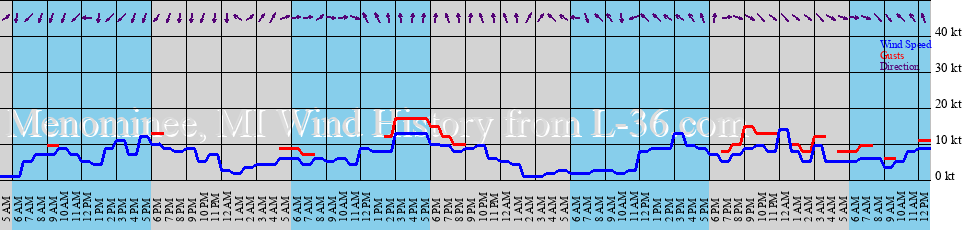
| MN4 - 9087088 - Menominee, MI | 22 mi | 54 min | SE 9.9G | 51°F | 54°F | 30.01 | 45°F | |
| FPTM4 - Fairport, MI | 42 mi | 44 min | WSW 4.1G | 54°F | ||||
| 45002 - N MICHIGAN- Halfway between North Manitou and Washington Islands. | 43 mi | 34 min | W 3.9G | 45°F | 41°F | 0 ft | 30.10 | 41°F |
toggle option: (graph/table)
Airport Reports
EDIT (hide/show) Help Click EDIT to display multiple airports. Follow links for more data.| Airport | Dist | Age | Wind kt | Vis | Sky | Weather | Temp | DewPt | RH | inHg |
| KMNM MENOMINEE RGNL,MI | 24 sm | 26 min | SE 12 | 10 sm | A Few Clouds | 61°F | 45°F | 55% | 30.06 |


Green Bay, WI,

NOTICE: Some pages have affiliate links to Amazon. As an Amazon Associate, I earn from qualifying purchases. Please read website Cookie, Privacy, and Disclamers by clicking HERE. To contact me click HERE. For my YouTube page click HERE