Welcome to L-36.com
Dedicated to the enjoyment of sailing
Weather and Tides
Ninety percent of the visitors to L-36.com come here because it is the best sailing weather site there is. If that is what you came for, click HERE. If you want more, I invite you to explore this site. There are literally thousands of pages on this site. Some specifically for your boat! The rest of this home page is going to highlight one application that I came to re-appreciate lately. Below is the story.A note to those looking for the old "Weather Index". All those links are now on the main Weather page. Much more convent.
PHP 8, GPS Marks, and Routes
PHP 8.1 Upgrade
The upgrade required editing probably 1000 files. In the process many programs that have been on the site for many years were looked at with fresh eyes and I want to highlight one set of pages in particular that stood out. I am highlighting it because it is a very useful and powerful set of programs that is not available anywhere else. It also had substantial edits in the upgrade process and works better than ever.
GPX File Generator
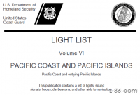
The Coast Guard publishes a list of all marks in U.S. Waters called the Light Lists. Once a week we download all the lists to our werver. One of the users of the site wrote a program that runs on this server and decodes the Coast Guard data. Thank you Norbert! It creates a database of all the marks, their latitude and longitude, their name and description. Here is one entry.| 44.936111 | -75.009253 | Wilson Hill Small boat Channel Buoy 6 | Red nun |
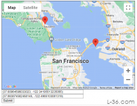
When you are satisfied with your list of marks, it is time to enter any routes you want to have included in your gpx file. If you enter waypoints.php page without first selecting any marks, or hit the "Clear" button on that page, you can see an example of a few waypoints and routes.
Once you have all your marks and routes entered press "Download gpx file" and the program will put a file in your download directory that can be downloaded to your GPS or imported into programs like Open CPN.
I made a video years ago. I hope you enjoy it.
And finally, HERE is my original write up on the Light List programs. I recommend reading it if you are interested in using the program.
Past Home Pages
001 - April 2023NOTICE: Some pages have affiliate links to Amazon. As an Amazon Associate, I earn from qualifying purchases. Please read website Cookie, Privacy, and Disclamers by clicking HERE. To contact me click HERE. For my YouTube page click HERE