Navigation
Easy GPS Waypoints and Routes Creation
By Allen Edwards
NOTE: Here is a quick link to the chart interface discussed in this article:
http://l-36.com/light_list_map.php
Building a Web App
This winter I am racing on a Tartan-10, not my L-36. We are racing the winter series out of South Beach Yacht Club and another one out of the Golden Gate Yacht Club. The skipper doesn't use a GPS and as I find them indispensable in sailing to a mark and in calling the layline, I brought my wrist version along. But first I needed to program in the waypoints and routes. What a pain. I used OpenCPN and plunked a waypoint down over the marks on the chart. Entering the courses (routes in the GPS) was the most difficult. That led me to build the waypoint and route editor. Then I thought, wouldn't it be great to just have a list of all the marks in the area and just check them off, rename them to match the names the race committee uses, import them into a program, copy and paste the race committee courses onto a page and press a button (after a little editing perhaps) and have a file you could download into your GPS? So I built just that.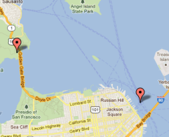 My journey started trying to find a list of all the marks in the country. I eventually found the 7 volume USCG Light List. It lists all the lighted marks, which is most of them. I had a list of the racing marks in SF Bay so I included that and created a database of all these marks.
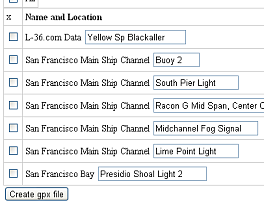
At that point you could look up the latitude and longitude of any of these marks. You just selected the region (which of the 7 volumes you wanted) and within that region, which chart the mark of interest might be on. At that point I thought, wouldn't it be nice to be able to select marks and load them automatically into the waypoint editor. That was a very simple change and suddenly you could check off marks and edit them in the build editor.
 In using that, some people had difficulty finding which chart had their marks. Sometimes there were marks on several charts in the area they sail. It was logical next step to make an interface that defined a latitude-longitude square and, by creating a database of area covered by each chart, identify which chart overlapped the area of interest. From there I made the program search each of the selected charts and only list marks that fall inside the square of interest. So now you can select an area on a map, list all the waypoint in that area, select the ones of interest, and transfer them automatically to an editor.
In using the tool set that had developed at this point some additional enhancements seemed important. One was to be able to include not only the .gpx data that the waypoint editor can take as input, but normal tab delineated text files like you would get by copying and pasting a table of marks and positions off a web site such as this one. Of course, I loaded that one into the data base, but any file like that can be loaded into the waypoint editor. I should point out that the waypoint editor can take multiple instances of inputs from the Light List data as well as a file in either .gpx or .txt format at the same time along with the ability to ask for any number of blank lines.
At this point the tools were getting very useful. The last thing I added was the ability to edit the names of the marks in the Light List database. That is important because any edits you do in the waypoint editor are erased if you add more waypoints and it seemed that the right place to edit the names is where you can see the descriptive data on the mark.
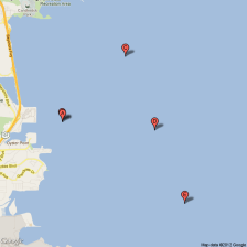 The waypoint editor is nice because you can edit all your waypoints and routes all on one page. You can view all the waypoints on a map to make sure you have them right. But the real benefit is the ability to copy and paste, edit if needed to meet the format, and get your routes (courses). This greatly reduces the chance for error, which is what was happening to me in trying to go from a piece of paper to clicking on waypoints on the GPS screen.
To get the waypoints into your GPS you might be able to do it with bluetooth, or just copy the file to your GPS connected to a USB cable. Some units use NEMA and require a serial to USB cable MonoPrice has one right now for $5.54 free shipping. If you need to download, you can use software that came with your unit or free software like EasyGPS, which is free.
I hope you enjoy this program. Be sure to visit the overview, which goes into detail showing how to use the programs. Light List Overview.
NOTICE: Some pages have affiliate links to Amazon. As an Amazon Associate, I earn from qualifying purchases. Please read website Cookie, Privacy, and Disclamers by clicking HERE. To contact me click HERE. For my YouTube page click HERE