Marine Weather and Tide Forecast for Cedar Mill, OR
 | Sunrise 6:56 AM Sunset 7:13 PM Moonrise 3:40 PM Moonset 12:00 AM |
Marine Forecasts
NOTE: Zones updated 4/16/2026. Some zones changed. Use Edit if needed.
PZZ210 Columbia River Bar- 108 Am Pdt Sun Sep 20 2026
In the main channel -
General seas - 3 ft building to 4 ft Monday morning.
First ebb - Ebb current of 3.49 kt at 1203 am Sunday. Seas 3 ft.
SEcond ebb - Ebb current of 1.65 kt at 1256 pm Sunday. Seas 3 ft.
Third ebb - Ebb current of 3.65 kt at 111 am Monday. Seas 4 ft.
PZZ200 108 Am Pdt Sun Sep 20 2026
Synopsis for the southern washington and northern oregon coast - High pressure will maintain northerly winds across the waters through Thursday. Northerly winds increase on Sunday, strongest during the late afternoon and early evening hours over the inner waters with isolated gusts up to 21-23 kt. Seas remain around 3 to 5 ft through the weekend, before increasing to 6 to 8 ft early next week.
7 Day Forecast for Marine Location Near Cedar Mill, OR

NEW! Add second zone forecast
| Vancouver Click for Map Note: See station comments in 'about' for disclaimers. Sun -- 12:08 AM PDT Moonset Sun -- 12:27 AM PDT 1.95 feet High Tide Sun -- 06:55 AM PDT Sunrise Sun -- 10:41 AM PDT 0.25 feet Low Tide Sun -- 03:57 PM PDT 1.30 feet High Tide Sun -- 04:39 PM PDT Moonrise Sun -- 07:11 PM PDT Sunset Sun -- 08:06 PM PDT 0.70 feet Low Tide Tide / Current data from XTide NOT FOR NAVIGATION |
Vancouver, Columbia River, Washington, Tide feet
| 12 am |
| 1.9 |
| 1 am |
| 1.9 |
| 2 am |
| 1.8 |
| 3 am |
| 1.6 |
| 4 am |
| 1.4 |
| 5 am |
| 1.2 |
| 6 am |
| 1.1 |
| 7 am |
| 0.9 |
| 8 am |
| 0.7 |
| 9 am |
| 0.5 |
| 10 am |
| 0.3 |
| 11 am |
| 0.3 |
| 12 pm |
| 0.4 |
| 1 pm |
| 0.7 |
| 2 pm |
| 1 |
| 3 pm |
| 1.2 |
| 4 pm |
| 1.3 |
| 5 pm |
| 1.2 |
| 6 pm |
| 1 |
| 7 pm |
| 0.8 |
| 8 pm |
| 0.7 |
| 9 pm |
| 0.8 |
| 10 pm |
| 1 |
| 11 pm |
| 1.2 |
| Portland Click for Map Sun -- 12:08 AM PDT Moonset Sun -- 06:55 AM PDT Sunrise Sun -- 09:51 AM PDT 0.45 feet Low Tide Sun -- 03:11 PM PDT 1.91 feet High Tide Sun -- 04:38 PM PDT Moonrise Sun -- 06:57 PM PDT 1.04 feet Low Tide Sun -- 07:11 PM PDT Sunset Tide / Current data from XTide NOT FOR NAVIGATION |
Portland, Morrison Street Bridge, Oregon, Tide feet
| 12 am |
| 2.6 |
| 1 am |
| 2.3 |
| 2 am |
| 2 |
| 3 am |
| 1.8 |
| 4 am |
| 1.7 |
| 5 am |
| 1.6 |
| 6 am |
| 1.4 |
| 7 am |
| 1.2 |
| 8 am |
| 0.9 |
| 9 am |
| 0.6 |
| 10 am |
| 0.5 |
| 11 am |
| 0.7 |
| 12 pm |
| 1.1 |
| 1 pm |
| 1.5 |
| 2 pm |
| 1.8 |
| 3 pm |
| 1.9 |
| 4 pm |
| 1.8 |
| 5 pm |
| 1.5 |
| 6 pm |
| 1.2 |
| 7 pm |
| 1 |
| 8 pm |
| 1.1 |
| 9 pm |
| 1.4 |
| 10 pm |
| 1.7 |
| 11 pm |
| 2.1 |
FXUS66 KPQR 201757 AAB AFDPQR
Area Forecast Discussion...UPDATED National Weather Service Portland OR 1056 AM PDT Sun Sep 20 2026
Updated aviation discussion
SYNOPSIS
Areas of fog and low clouds Sunday morning will give way to sunny and warm conditions in the afternoon. Temperatures trend cooler Monday through Friday as upper level troughing develops over the Gulf of Alaska. Chances for rain have increased Thursday night into Friday to 40-60% as troughing attempts pushing into western Washington and western Oregon.
SHORT TERM
Now through Wednesday...Guidance is in strong agreement that a broad but low-amplitude ridge will steadily shift eastward through the middle of next week while being replaced by an upper-level trough digging southward over the Gulf of Alaska. Upper level flow will become southwesterly over Washington and Oregon ahead of the aforementioned trough, with no signs of any significant moisture pushing inland. As such, the forecast remains dry through Wednesday. After upper level heights peak on Sunday, mid-level temperatures will begin to trend downward Monday through Wednesday, which will bring a cooling trend across the region.
Surface temperatures will reach around 4-7 degrees above normal over inland areas Sunday afternoon after areas of morning fog and low clouds lift, with highs most likely in the upper 70s to low 80s over the lowlands. Meanwhile, temperatures will remain near normal at the coast in the 60s. As onshore flow strengthens Monday through Wednesday and temperatures cool aloft, surface temperatures will steadily cool be a few degrees each day over inland areas. Otherwise, longer nights and light winds will favor periods of early morning fog in sheltered valleys each day, with a typical fall pattern of low clouds pushing inland overnight and clearing through the day. -23
LONG TERM
Wednesday night through Saturday night...The forecast remains dry and mild Wednesday night through Thursday afternoon as dry southwest flow aloft persists. However, chances for rain Thursday night into Friday have increased due to an uptick in the number of ensemble members showing at least some QPF over the area with an approaching upper level trough. Chances for precipitation falling within a 24-hour period ending at 5 PM Friday have increased to 40-60%. Exact timing and rain amounts remain uncertain, and around 30-40% of ensemble guidance continues to show no rain at all over the Willamette Valley. Therefore, confidence is only moderate and it is too soon to tell if Friday will for sure be a wet day or not.
Regardless of the outcome, chances for rain decrease significantly Friday night into Saturday to less than 15%, suggesting multiple days with rain are unlikely.
It is also worth mentioning that chances for frost increase over the Upper Hood River Valley Friday night and Saturday night when there is a 30-50% chance for overnight lows around 37 degrees or colder, mainly in the Parkdale area. Probabilities are around 10% in Odell and 1-5% in Hood River. Those with sensitive outdoor vegetation in this area should monitor the forecast over the coming days. -23
AVIATION
Through 18Z Monday...Satellite imagery and terminal observations as of late Sunday morning depicts predominately IFR/LIFR stratus across the Willamette Valley and coast as high pressure keeps CIGs low. Stratus is beginning to gradually dissipate and should clear out for most terminals by 20-21z Sun as daytime heating progresses. An exception would be the central Oregon coast including KONP, where IFR stratus may linger throughout the day. VFR conditions prevail across the Valley through late tonight.
This evening after 00-03z Mon, there is high confidence (>80%) for a return of IFR/MVFR stratus along the coast. Similar to previous mornings, will see a return of stratus across the Valley between 12- 18z Mon with a 30-50% chance for MVFR CIGs at any given hour. Unlike today, high pressure aloft will move eastward tomorrow, so CIGs may not be as low tomorrow (10-20% chance for IFR at any given hour across the Valley). However, given that we'll get decent onshore flow from an approaching trough, stratus tomorrow morning could linger longer into the afternoon. North/northwesterly winds today under 10 kt for most terminals except 10-15 kt with gusts up to 25 kt at KONP.
KPDX AND APPROACHES...IFR CIGs and MVFR VIS through 19-20z Sun.
Afterwards, VFR conditions prevail through late tonight. MVFR stratus returns after 12z Mon, with a 10-20% chance for IFR CIGs at any given hour between 12-18z Mon. Northwesterly winds 4-6 kt today, weakening overnight. -10
MARINE
High pressure over the waters will maintain northerly winds through this weekend. Northerly winds peak in strength Sunday afternoon and evening when there is a 50-90% chance for maximum wind gusts of 21 kt or slightly stronger across the waters, with the highest chances across the inner waters out to 10 NM offshore. Given wind gusts of this magnitude are not expected to be frequent or widespread, Small Craft Advisories are not anticipated at this time. Significant wave heights will remain around 3 to 5 ft through the weekend, mainly driven by a persistent northwesterly swell with a dominant wave period near 7 seconds.
Northerly winds are expected to linger Monday through Wednesday, with wind gusts generally staying under 20 kt. A long period west-northwesterly swell is set to arrive either Monday afternoon or evening, pushing seas up by one to two feet. However, seas will not be particularly steep as the dominant wave period with this swell will be around 11-13 seconds. -23
PQR WATCHES/WARNINGS/ADVISORIES
OR...None.
WA...None.
PZ...None.
Area Forecast Discussion...UPDATED National Weather Service Portland OR 1056 AM PDT Sun Sep 20 2026
Updated aviation discussion
SYNOPSIS
Areas of fog and low clouds Sunday morning will give way to sunny and warm conditions in the afternoon. Temperatures trend cooler Monday through Friday as upper level troughing develops over the Gulf of Alaska. Chances for rain have increased Thursday night into Friday to 40-60% as troughing attempts pushing into western Washington and western Oregon.
SHORT TERM
Now through Wednesday...Guidance is in strong agreement that a broad but low-amplitude ridge will steadily shift eastward through the middle of next week while being replaced by an upper-level trough digging southward over the Gulf of Alaska. Upper level flow will become southwesterly over Washington and Oregon ahead of the aforementioned trough, with no signs of any significant moisture pushing inland. As such, the forecast remains dry through Wednesday. After upper level heights peak on Sunday, mid-level temperatures will begin to trend downward Monday through Wednesday, which will bring a cooling trend across the region.
Surface temperatures will reach around 4-7 degrees above normal over inland areas Sunday afternoon after areas of morning fog and low clouds lift, with highs most likely in the upper 70s to low 80s over the lowlands. Meanwhile, temperatures will remain near normal at the coast in the 60s. As onshore flow strengthens Monday through Wednesday and temperatures cool aloft, surface temperatures will steadily cool be a few degrees each day over inland areas. Otherwise, longer nights and light winds will favor periods of early morning fog in sheltered valleys each day, with a typical fall pattern of low clouds pushing inland overnight and clearing through the day. -23
LONG TERM
Wednesday night through Saturday night...The forecast remains dry and mild Wednesday night through Thursday afternoon as dry southwest flow aloft persists. However, chances for rain Thursday night into Friday have increased due to an uptick in the number of ensemble members showing at least some QPF over the area with an approaching upper level trough. Chances for precipitation falling within a 24-hour period ending at 5 PM Friday have increased to 40-60%. Exact timing and rain amounts remain uncertain, and around 30-40% of ensemble guidance continues to show no rain at all over the Willamette Valley. Therefore, confidence is only moderate and it is too soon to tell if Friday will for sure be a wet day or not.
Regardless of the outcome, chances for rain decrease significantly Friday night into Saturday to less than 15%, suggesting multiple days with rain are unlikely.
It is also worth mentioning that chances for frost increase over the Upper Hood River Valley Friday night and Saturday night when there is a 30-50% chance for overnight lows around 37 degrees or colder, mainly in the Parkdale area. Probabilities are around 10% in Odell and 1-5% in Hood River. Those with sensitive outdoor vegetation in this area should monitor the forecast over the coming days. -23
AVIATION
Through 18Z Monday...Satellite imagery and terminal observations as of late Sunday morning depicts predominately IFR/LIFR stratus across the Willamette Valley and coast as high pressure keeps CIGs low. Stratus is beginning to gradually dissipate and should clear out for most terminals by 20-21z Sun as daytime heating progresses. An exception would be the central Oregon coast including KONP, where IFR stratus may linger throughout the day. VFR conditions prevail across the Valley through late tonight.
This evening after 00-03z Mon, there is high confidence (>80%) for a return of IFR/MVFR stratus along the coast. Similar to previous mornings, will see a return of stratus across the Valley between 12- 18z Mon with a 30-50% chance for MVFR CIGs at any given hour. Unlike today, high pressure aloft will move eastward tomorrow, so CIGs may not be as low tomorrow (10-20% chance for IFR at any given hour across the Valley). However, given that we'll get decent onshore flow from an approaching trough, stratus tomorrow morning could linger longer into the afternoon. North/northwesterly winds today under 10 kt for most terminals except 10-15 kt with gusts up to 25 kt at KONP.
KPDX AND APPROACHES...IFR CIGs and MVFR VIS through 19-20z Sun.
Afterwards, VFR conditions prevail through late tonight. MVFR stratus returns after 12z Mon, with a 10-20% chance for IFR CIGs at any given hour between 12-18z Mon. Northwesterly winds 4-6 kt today, weakening overnight. -10
MARINE
High pressure over the waters will maintain northerly winds through this weekend. Northerly winds peak in strength Sunday afternoon and evening when there is a 50-90% chance for maximum wind gusts of 21 kt or slightly stronger across the waters, with the highest chances across the inner waters out to 10 NM offshore. Given wind gusts of this magnitude are not expected to be frequent or widespread, Small Craft Advisories are not anticipated at this time. Significant wave heights will remain around 3 to 5 ft through the weekend, mainly driven by a persistent northwesterly swell with a dominant wave period near 7 seconds.
Northerly winds are expected to linger Monday through Wednesday, with wind gusts generally staying under 20 kt. A long period west-northwesterly swell is set to arrive either Monday afternoon or evening, pushing seas up by one to two feet. However, seas will not be particularly steep as the dominant wave period with this swell will be around 11-13 seconds. -23
PQR WATCHES/WARNINGS/ADVISORIES
OR...None.
WA...None.
PZ...None.
| Stations | Dist | Age | Wind | Air | Water | Waves | inHg | DewPt |
| KLMW1 | 28 mi | 53 min | 30.07 | |||||
| LOPW1 - 9440422 - Longview, WA | 38 mi | 53 min | 66°F | 30.10 |
Wind History for Astoria, OR
toggle option: (graph/table)
| Airport | Dist | Age | Wind kt | Vis | Sky | Weather | Air | DewPt | RH | inHg |
| KVUO Pearson Field US | 7 sm | 29 min | NW 04 | 10 sm | Overcast | 59°F | 54°F | 82% | 30.09 | |
| KPDX Portland International Airport US | 9 sm | 29 min | var 04 | 7 sm | Overcast | 61°F | 55°F | 82% | 30.08 | |
| KHIO Portland Hillsboro Airport US | 10 sm | 29 min | calm | 10 sm | Partly Cloudy | 63°F | 55°F | 77% | 30.06 | |
| KSPB Scappoose Industrial Airpark US | 14 sm | 29 min | NNE 08 | 10 sm | Clear | 63°F | 54°F | 72% | 30.06 | |
| KTTD Portland Troutdale Airport US | 20 sm | 29 min | var 04 | 10 sm | Overcast | 57°F | 55°F | 94% | 30.07 | |
| KUAO Aurora State Airport US | 23 sm | 29 min | NNE 06 | 9 sm | Overcast | 57°F | 55°F | 94% | 30.08 |
Link to 5 hour of 5 minute data for KVUO
Terminal Aerodrome Forecast (TAF) for KVUO
Wind History Graph: VUO
(wind in knots)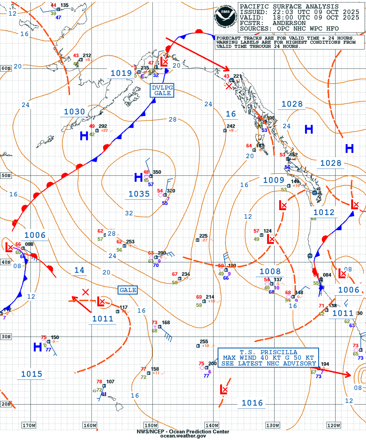
GEOS Local Image of Pacific Northwest
Edit Hide

Portland, OR,

NOTICE: Some pages have affiliate links to Amazon. As an Amazon Associate, I earn from qualifying purchases. Please read website Cookie, Privacy, and Disclamers by clicking HERE. To contact me click HERE. For my YouTube page click HERE
X