Marine Weather and Tide Forecast for Pelican, AK
 | Sunrise 6:39 AM Sunset 7:02 PM Moonrise 4:54 PM Moonset 10:55 PM |
Marine Forecasts
NOTE: Zones updated 4/16/2026. Some zones changed. Use Edit if needed.
PKZ643 Cape Edgecumbe To Cape Spencer Out To 15 Nm- 336 Pm Akdt Sun Sep 20 2026
.small craft advisory through Monday - .
Tonight - S wind 30 kt diminishing to 20 kt late. Seas 19 ft subsiding to 15 ft late. Showers with a chance of Thunderstorms. Showers late.
Mon - S wind 15 kt. Seas 10 ft. Showers and chance of Thunderstorms in the morning, then slight chance of Thunderstorms in the afternoon.
Mon night - S wind 10 kt becoming E 20 kt late. Seas 8 ft. SW swell. Slight chance of Thunderstorms in the evening.
Tue - E wind 25 kt. Seas 11 ft. Rain.
Tue night - SE wind 25 kt. Seas 11 ft. Showers.
Wed - SE wind 25 kt. Seas 10 ft.
Thu - E wind 15 kt. Seas 7 ft.
Fri - SE wind 15 kt. Seas 5 ft.
PKZ600
No data
No data
7 Day Forecast for Marine Location Near Pelican, AK

NEW! Add second zone forecast
| Canoe Cove Click for Map Sun -- 02:59 AM AKDT 2.15 feet Low Tide Sun -- 06:46 AM AKDT Sunrise Sun -- 10:16 AM AKDT 6.55 feet High Tide Sun -- 03:03 PM AKDT 5.06 feet Low Tide Sun -- 05:53 PM AKDT Moonrise Sun -- 07:09 PM AKDT Sunset Sun -- 08:53 PM AKDT 7.78 feet High Tide Sun -- 11:55 PM AKDT Moonset Tide / Current data from XTide NOT FOR NAVIGATION |
Canoe Cove, North Pass, Lisianski Strait, Alaska, Tide feet
| 12 am |
| 4 |
| 1 am |
| 3.1 |
| 2 am |
| 2.4 |
| 3 am |
| 2.1 |
| 4 am |
| 2.4 |
| 5 am |
| 3 |
| 6 am |
| 3.8 |
| 7 am |
| 4.8 |
| 8 am |
| 5.7 |
| 9 am |
| 6.3 |
| 10 am |
| 6.5 |
| 11 am |
| 6.5 |
| 12 pm |
| 6.1 |
| 1 pm |
| 5.7 |
| 2 pm |
| 5.2 |
| 3 pm |
| 5.1 |
| 4 pm |
| 5.2 |
| 5 pm |
| 5.7 |
| 6 pm |
| 6.4 |
| 7 pm |
| 7.1 |
| 8 pm |
| 7.6 |
| 9 pm |
| 7.8 |
| 10 pm |
| 7.5 |
| 11 pm |
| 6.7 |
| Lisianski Strait Click for Map Flood direction 64 true Ebb direction 268 true Sun -- 03:01 AM AKDT 0.98 knots Max Flood Sun -- 06:46 AM AKDT Sunrise Sun -- 08:37 AM AKDT -0.00 knots Slack Sun -- 11:39 AM AKDT -0.35 knots Max Ebb Sun -- 01:16 PM AKDT 0.00 knots Slack Sun -- 05:18 PM AKDT 1.31 knots Max Flood Sun -- 05:54 PM AKDT Moonrise Sun -- 07:09 PM AKDT Sunset Sun -- 09:22 PM AKDT -0.00 knots Slack Sun -- 11:21 PM AKDT -0.24 knots Max Ebb Sun -- 11:53 PM AKDT Moonset Tide / Current data from XTide NOT FOR NAVIGATION |
Lisianski Strait, north of Rock Point (depth 14 ft), Cross Sound, Alaska Current, knots
| 12 am |
| 0.2 |
| 1 am |
| 0.6 |
| 2 am |
| 0.9 |
| 3 am |
| 1 |
| 4 am |
| 0.9 |
| 5 am |
| 0.8 |
| 6 am |
| 0.6 |
| 7 am |
| 0.3 |
| 8 am |
| 0.1 |
| 9 am |
| -0 |
| 10 am |
| -0.2 |
| 11 am |
| -0.3 |
| 12 pm |
| -0.3 |
| 1 pm |
| -0.1 |
| 2 pm |
| 0.3 |
| 3 pm |
| 0.7 |
| 4 pm |
| 1.1 |
| 5 pm |
| 1.3 |
| 6 pm |
| 1.2 |
| 7 pm |
| 0.9 |
| 8 pm |
| 0.4 |
| 9 pm |
| 0.1 |
| 10 pm |
| -0.1 |
| 11 pm |
| -0.2 |
FXAK67 PAJK 210010 AFDAJK
Southeast Alaska Forecast Discussion National Weather Service Juneau AK 410 PM AKDT Sun Sep 20 2026
SYNOPSIS
Key Messages:
- Thunderstorms mostly along the outer coast for the NE gulf coast and some parts of the inner channels
- A Flood Watch continues for the northern panhandle due to heavy rain and ice melt occurring through the weekend.
- Wind advisories are up for parts of the panhandle for gusts of 40 to 55 mph.
- Cooler but seasonable temperatures for the period, with daytime highs generally in the 50s.
SHORT TERM
The low pressure that has been affecting Southeast Alaska has started to weaken as it interacts with the northern Gulf coast.
This low will continue to weaken through the overnight hours this evening as the center moves towards Prince William Sound. While the low remains in the area, showers and thunderstorms will still be possible going into tomorrow for the panhandle. Some of these showers could be gusty and have heavy periods of rain. As the low moves back into the Gulf on Monday, it is expected to interact with the next low moving into the Gulf of Alaska Monday night into early Tuesday morning. With this next system, there could be some gusty winds, especially for locations along the outer coast but the gradient otherwise looks to be less significant than what we've seen today. The pattern for the short term continues to look active with more rain and wind moving into the area heading into the middle of the week.
LONG TERM
/Tuesday through Friday/
An active pattern continues into the beginning of the week as a low redevelops in the central Gulf, continuing to bring waves of precipitation with showery onshore flow between them lasting through midweek. The low appears to redevelop around 140W early Tuesday morning, looking notably less strong than the current system in the Gulf that impacted the area this weekend. It is expected to bring another more organized wave of precipitation northward across the panhandle during the day Tuesday, followed by a few less organized and showery waves Wednesday into Thursday. This midweek low looks to be a bit more aligned today between models on the main precipitation band moving through Tuesday, with all of them appearing to shift the low and front southward a bit compared to yesterday. Expecting much of the rainfall Tuesday to impact the southern panhandle at this time, with some areas around Ketchikan and Metlakatla seeing potential for up to 1 to 1.5 inches in 24 hours as the main band moves through. Some uncertainty still remains on timing and rainfall amounts, especially due to the more showery regime expected midweek and the spread on the low's track/location especially moving into Wednesday. Some guidance shows the low remaining further west, while some have it moving in towards the panhandle with the low center sitting east of 140W during the day Tuesday. This will also bring some lower confidence in some of the marine winds, depending on how far offshore or how close to the panhandle the main low center ends up moving to.
AVIATION
Aviation weather is not very good. Scattered to numerous thunderstorms are being observed along the entire outer coast. Some storms have even been observed as far inland as Stephens Passage and Wrangell this morning. In addition a few pilot reports have been received of turbulence, wind shear, and thunderstorms around the area including one report of severe turbulence in Taiya Inlet at 1500 ft and some +/- 15 kt wind shear at Juneau. Gusty winds are also continuing with surface gusts reaching 35 kt in some locations and winds aloft around 2000 ft around 25 to 35 kt so some low level wind shear is possible especially along the outer coast. All of these conditions are largely expected to continue this evening with the thunderstorm potential spreading SE into the southern panhandle. Into later tonight, winds, turbulence, and low level wind shear should start to subside and will continue to subside into Monday. The thunderstorm potential is expected to persist into Monday but will start to diminish from NW to SE through the day. Expect gusty winds, and vis and ceiling possibly down to IFR in the stronger showers and lightning near the thunderstorms.
MARINE
Inside(Inner Channels): A strong low continues to push inland near Prince William Sound Sunday afternoon. An associated front has lifted inland over the panhandle, bringing persistent southerly and easterly winds throughout the day. The strongest winds will continue along Lynn Canal Sunday night, particularly in the vicinity of Taiya Inlet which will see sustained winds up to 35 kt and gusts up to 45 kt through late tonight. Winds will diminish late Sunday into Monday with a short break over the panhandle before the next system moves into the area by Tuesday.
Outside (Gulf and Coastal Waters): Winds and waves have started to trend downwards as the low in the northern gulf continues to push into Prince William Sound. As of this discussion, winds in the gulf have fallen to 25 kt or less, but erratic gusts up to gale force or stronger are still possible in the vicinity of strong convective showers that continue to develop, and remain possible through Monday morning. Along with these strong winds, significant wave heights that reached as high as 15 to 20 ft across the gulf have begun to subside and will continue to do so through Monday. Active weather is still in store for mid week as winds once again increase across the gulf into Tuesday.
AJK WATCHES/WARNINGS/ADVISORIES
PUBLIC...Wind Advisory until 4 PM AKDT this afternoon for AKZ317-320>325- 327.
Flood Watch through late tonight for AKZ318-319.
Wind Advisory until 4 AM AKDT Monday for AKZ318-319.
MARINE...Gale Warning for PKZ012.
Small Craft Advisory for PKZ011-013-021-022-031>034-053-641>644- 651-652-661>664-671-672.
Southeast Alaska Forecast Discussion National Weather Service Juneau AK 410 PM AKDT Sun Sep 20 2026
SYNOPSIS
Key Messages:
- Thunderstorms mostly along the outer coast for the NE gulf coast and some parts of the inner channels
- A Flood Watch continues for the northern panhandle due to heavy rain and ice melt occurring through the weekend.
- Wind advisories are up for parts of the panhandle for gusts of 40 to 55 mph.
- Cooler but seasonable temperatures for the period, with daytime highs generally in the 50s.
SHORT TERM
The low pressure that has been affecting Southeast Alaska has started to weaken as it interacts with the northern Gulf coast.
This low will continue to weaken through the overnight hours this evening as the center moves towards Prince William Sound. While the low remains in the area, showers and thunderstorms will still be possible going into tomorrow for the panhandle. Some of these showers could be gusty and have heavy periods of rain. As the low moves back into the Gulf on Monday, it is expected to interact with the next low moving into the Gulf of Alaska Monday night into early Tuesday morning. With this next system, there could be some gusty winds, especially for locations along the outer coast but the gradient otherwise looks to be less significant than what we've seen today. The pattern for the short term continues to look active with more rain and wind moving into the area heading into the middle of the week.
LONG TERM
/Tuesday through Friday/
An active pattern continues into the beginning of the week as a low redevelops in the central Gulf, continuing to bring waves of precipitation with showery onshore flow between them lasting through midweek. The low appears to redevelop around 140W early Tuesday morning, looking notably less strong than the current system in the Gulf that impacted the area this weekend. It is expected to bring another more organized wave of precipitation northward across the panhandle during the day Tuesday, followed by a few less organized and showery waves Wednesday into Thursday. This midweek low looks to be a bit more aligned today between models on the main precipitation band moving through Tuesday, with all of them appearing to shift the low and front southward a bit compared to yesterday. Expecting much of the rainfall Tuesday to impact the southern panhandle at this time, with some areas around Ketchikan and Metlakatla seeing potential for up to 1 to 1.5 inches in 24 hours as the main band moves through. Some uncertainty still remains on timing and rainfall amounts, especially due to the more showery regime expected midweek and the spread on the low's track/location especially moving into Wednesday. Some guidance shows the low remaining further west, while some have it moving in towards the panhandle with the low center sitting east of 140W during the day Tuesday. This will also bring some lower confidence in some of the marine winds, depending on how far offshore or how close to the panhandle the main low center ends up moving to.
AVIATION
Aviation weather is not very good. Scattered to numerous thunderstorms are being observed along the entire outer coast. Some storms have even been observed as far inland as Stephens Passage and Wrangell this morning. In addition a few pilot reports have been received of turbulence, wind shear, and thunderstorms around the area including one report of severe turbulence in Taiya Inlet at 1500 ft and some +/- 15 kt wind shear at Juneau. Gusty winds are also continuing with surface gusts reaching 35 kt in some locations and winds aloft around 2000 ft around 25 to 35 kt so some low level wind shear is possible especially along the outer coast. All of these conditions are largely expected to continue this evening with the thunderstorm potential spreading SE into the southern panhandle. Into later tonight, winds, turbulence, and low level wind shear should start to subside and will continue to subside into Monday. The thunderstorm potential is expected to persist into Monday but will start to diminish from NW to SE through the day. Expect gusty winds, and vis and ceiling possibly down to IFR in the stronger showers and lightning near the thunderstorms.
MARINE
Inside(Inner Channels): A strong low continues to push inland near Prince William Sound Sunday afternoon. An associated front has lifted inland over the panhandle, bringing persistent southerly and easterly winds throughout the day. The strongest winds will continue along Lynn Canal Sunday night, particularly in the vicinity of Taiya Inlet which will see sustained winds up to 35 kt and gusts up to 45 kt through late tonight. Winds will diminish late Sunday into Monday with a short break over the panhandle before the next system moves into the area by Tuesday.
Outside (Gulf and Coastal Waters): Winds and waves have started to trend downwards as the low in the northern gulf continues to push into Prince William Sound. As of this discussion, winds in the gulf have fallen to 25 kt or less, but erratic gusts up to gale force or stronger are still possible in the vicinity of strong convective showers that continue to develop, and remain possible through Monday morning. Along with these strong winds, significant wave heights that reached as high as 15 to 20 ft across the gulf have begun to subside and will continue to do so through Monday. Active weather is still in store for mid week as winds once again increase across the gulf into Tuesday.
AJK WATCHES/WARNINGS/ADVISORIES
PUBLIC...Wind Advisory until 4 PM AKDT this afternoon for AKZ317-320>325- 327.
Flood Watch through late tonight for AKZ318-319.
Wind Advisory until 4 AM AKDT Monday for AKZ318-319.
MARINE...Gale Warning for PKZ012.
Small Craft Advisory for PKZ011-013-021-022-031>034-053-641>644- 651-652-661>664-671-672.
| Airport | Dist | Age | Wind kt | Vis | Sky | Weather | Air | DewPt | RH | inHg |
Link to 5 hour of 5 minute data for PAEL
Terminal Aerodrome Forecast (TAF) for PAEL
Wind History Graph: AEL
(wind in knots)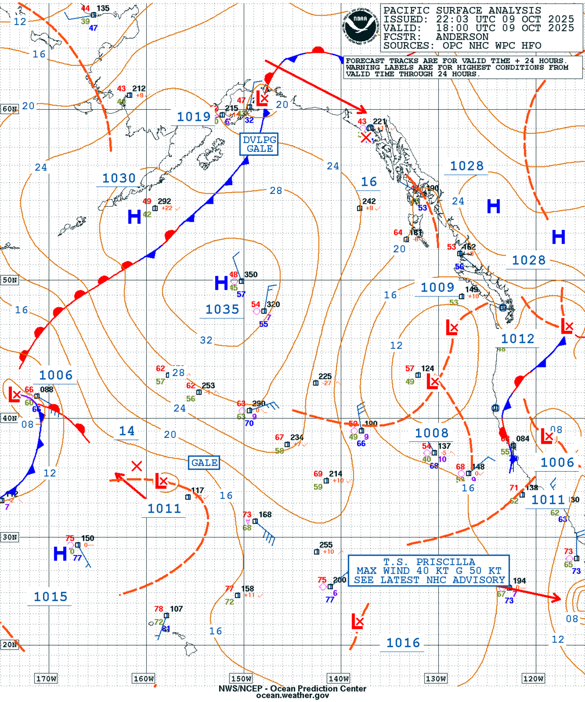
GEOS Local Image of Pacific Northwest
Edit Hide

Sitka/Juneau,AK

NOTICE: Some pages have affiliate links to Amazon. As an Amazon Associate, I earn from qualifying purchases. Please read website Cookie, Privacy, and Disclamers by clicking HERE. To contact me click HERE. For my YouTube page click HERE
X